


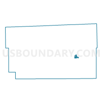
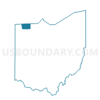
DELTA ONE, Fulton County, Ohio
About
Outline

Summary
| Unique Area Identifier | 646586 |
| Name | DELTA ONE |
| County | Fulton County |
| State | Ohio |
| Area (square miles) | 0.61 |
| Land Area (square miles) | 0.61 |
| Water Area (square miles) | 0.00 |
| % of Land Area | 99.95 |
| % of Water Area | 0.05 |
| Latitude of the Internal Point | 41.57840760 |
| Longtitude of the Internal Point | -83.99336090 |
Maps

Graphs
Select a template below for downloading or customizing gragh for DELTA ONE, Fulton County, Ohio


Neighbors
Neighoring Voting District (by Name) Neighboring Voting District on the Map
- DELTA THREE, Fulton County, OH
- DELTA TWO, Fulton County, OH
- FULTON, Fulton County, OH
- PIKE, Fulton County, OH
- SWANCREEK WEST ONE, Fulton County, OH
- YORK NORTH, Fulton County, OH
Top 10 Neighboring County Subdivision (by Population) Neighboring County Subdivision on the Map
- Swan Creek township, Fulton County, OH (8,566)
- York township, Fulton County, OH (4,145)
- Fulton township, Fulton County, OH (3,182)
- Pike township, Fulton County, OH (1,854)
Top 10 Neighboring Place (by Population) Neighboring Place on the Map
Top 10 Neighboring Unified School District (by Population) Neighboring Unified School District on the Map
Top 10 Neighboring State Legislative District Lower Chamber (by Population) Neighboring State Legislative District Lower Chamber on the Map
Top 10 Neighboring State Legislative District Upper Chamber (by Population) Neighboring State Legislative District Upper Chamber on the Map
Top 10 Neighboring 111th Congressional District (by Population) Neighboring 111th Congressional District on the Map
Top 10 Neighboring Census Tract (by Population) Neighboring Census Tract on the Map
- Census Tract 405, Fulton County, OH (4,899)
- Census Tract 404, Fulton County, OH (3,494)
- Census Tract 401, Fulton County, OH (3,286)